Smedsvig Landskapsarkitekter AS
Askevågen
This little vantage point with its panoramic view is located on the Atlantic Road.
- Architect:
- 3RW - Jakob Røssvik
- Landscape architect:
- Smedsvig Landskapsarkitekter AS
- Finished:
- 2005
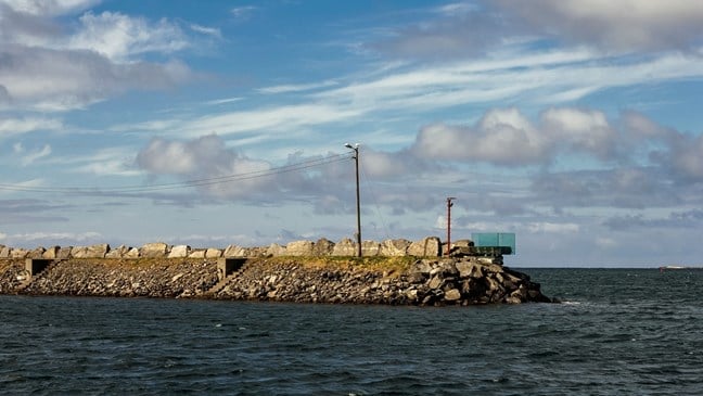
The viewing platform brings visitors in close contact with the Atlantic Ocean and the mighty forces of nature it embodies. The vantage point is built as a self-supporting construction in naval hull plates bolted to the existing breakwater, from where visitors can come even closer to the ocean and enjoy the panoramic view over the archipelago and the fishing port of Askvågen.
Flydalsjuvet
The rest area is located near the steep hillside at the end of the Geirangerfjord.
- Architect:
- 3RW - Sixten Rahlff
- Landscape architect:
- Smedsvig Landskapsarkitekter AS
- Finished:
- 2006
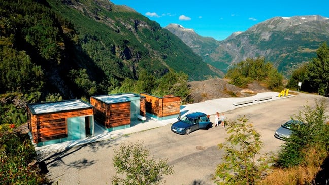
When designing the service facilities and information boards at Flydalsjuvet, the architect Sixten Rahlff kept local building traditions in mind. The rest area is located near the steep hillside at the end of the Geirangerfjord. Centuries-old construction timber was used for the service building and information stand. The old timber has been combined with translucent glass walls that let the light in while remaining opaque.
Flydalsjuvet contains three elements, which in addition to the service building encompass a car park and several vantage points connected by paths and walkways. The viewing platform at Flydalsjuvet gorge is designed with an upper and lower level connected by a walkway.
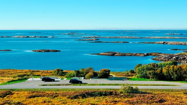
Geitøya
At Geitøya there is parking, a viewing point and a fishing pier. The fishing pier is designed with a particular view to universal accessibility.
- Landscape architect:
- Smedsvig Landskapsarkitekter AS
- Finished:
- 2010
From the bus stop and parking area a path has been constructed that leads to a fishing platform. The path has a maximum gradient of of 1:20 and has protective side-rails on both sides. The fishing platform itself is of a simple design in light, on-site cast concrete and is suspended 2-3 metres above the water.
Kjeksa
The vantage point at Kjeksa is located near the fishing hamlet of Bud on the Atlantic Road.
- Architect:
- 3RW - Jakob Røssvik
- Landscape architect:
- Smedsvig Landskapsarkitekter AS
- Finished:
- 2005
Here, the architect wished to design a rest area that would invite visitors to explore the landscape facing Hustadvika with its islets and skerries, an area where architecture helps emphasize the qualities of the landscape. The rest area has been placed around two old trees that constitute a central element framed by benches and gravel. The green gravel surface, a by-product from local smelters, is held in place by a hidden steel frame. A narrow path in light-coloured concrete follows the undulations of the landscape, leading you to the water’s edge.
Ørnesvingen
Ørnesvingen is one of two spectacular vantage points along the Norwegian Scenic Route Geiranger – Trollstigen.
- Architect:
- 3RW - Sixten Rahlff
- Landscape architect:
- Smedsvig Landskapsarkitekter AS
- Finished:
- 2006
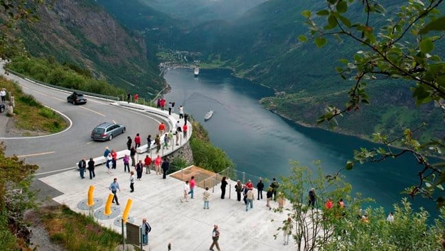
The site is located amidst scenic natural surroundings with a breathtaking view over the Geirangerfjord. The design objective has been to reinforce the experience of this dramatic and unique landscape.
The Ørnesvingen site consists of two parts. On “the balcony”, three slabs of white concrete have been cast in place at varying heights, creating a landscape of steps, benches and open spaces towards the fjord and the scenery. An existing stream runs over a glass plane across the site before hurtling over the edge down to the fjord. In “the curve”, a concrete floor protrudes out over the old abutment wall. Broad benches in prefabricated, ground white concrete follow the shape of the driving lane, separating motorists and pedestrians.
The viewing platform has a glass decoration made by the artist May Elin Eikaas-Bjerk.