Østengen og Bergo AS
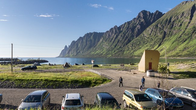
Ersfjordstranda
Ersfjord beach is located at the farthest end of Ersfjord on the island of Senja.
- Architect:
- Tupelo Arkitektur
- Landscape architect:
- Østengen og Bergo AS
- Finished:
- 2014
Tupelo Arkitektur:
The beach is surrounded by tall mountains on three sides, which form a magnificent landscape area. The white sandy beach is a popular recreational area. The beach borders sand dunes – a particular type of flora that is rear to find in Norway. On beautiful summer days, as many as 60 cars could be parked along the road and on the grassy field down towards the beach, causing chaos and excessive wear and tear on the vulnerable vegetation. A car park and a toilet facility were built in the area where the impact on nature would be minimal. The toilet facility has a triangular geometric shape that mirrors the surrounding mountains. The exterior is clad in Corten steel. The rust colour metal will ensure that the building will blend in with its surroundings regardless of the season. The inside of the toilet facility is clad with polished stainless steel. A glass roof fills the toilet facility with light and provides a view of the surrounding nature. With simple interior lighting, the building can be used as a lantern at night.
Østengen og Bergo AS:
On beautiful summer days, many cars were parked along the road and on the grassy fields and sand dunes at Ersfjordstranda. This led to traffic chaos and significant wear and tear on the fragile sand dune vegetation. Østengen & Bergo prepared a landscape analysis as a basis for assessing where a new car park could be located in the very vulnerable landscape.
The result of the analysis was a recommendation to design the car park in the least exposed area with the least valuable biotope. The recommended solution places the car park partly behind an existing sand dune. It was stressed that the car park should join the sand dune’s original shape without any encroachments. Placing toilet facilities, paths and sitting areas in the vulnerable terrain was also part of the assignment.
The service building is designed by Tupelo Arkitektur.
The rest area is designed by Østengen og Bergo AS.
Skjervsfossen
Skjervsfossen is a large nature attraction located at one of the gateways to Norwegian Scenic Route Hardanger.
- Architect:
- Fortunen AS - Nils Mannsåker
- Landscape architect:
- Østengen og Bergo AS
- Finished:
- 2016
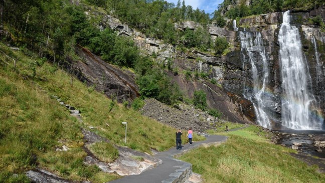
Wear and tear had taken its toll on the rest area and surroundings, and the waterfall was not easily accessible. A building that resembles a sturdy monolith is located by the parking facilities, where the nature walk begins. The building, which has toilet facilities and a small technical room//storeroom, has slate exterior walls. The interior is clad with plywood veneer; the wall facing the river and exterior doors are clad with galvanised sheets.
Footpaths and hikes that offer various ways to experience the waterfall have been created. Several of the footpaths have been universally designed and are easily accessible. Footpaths, steps and railings have been designed discreetly into the terrain, allowing Nature to play the lead. Skjervsfossen nature walk allows visitors to experience the waterfall in various ways and from various points. “The Edge” runs close to the edge of the waterfall, “the Shelf” and “the Lower Shelf” provide a dramatic and up-close view of the waterfall from two intermediary levels. “The Step” is located further into the landscape and connects the upper and lower levels. “The Shower” allows a close encounter with the wet element. At the beginning of the footpath that leads into the waterfall is a parking facility. Fortunen Architects has made a characteristic toilet, where the roof and walls are covered with large plates of natural stone, and with a steel door.
Sluppen
On the way up from Lærdalsøyri to Aurlandsfjellet you will find Sluppen and the gushing waterfall in the Vardahaugselvi river.
- Landscape architect:
- Østengen og Bergo AS
- Finished:
- 2023
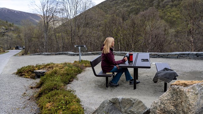
Here, what used to be a parking lay-by has now been upgraded to a simple rest area with room for four cars and a picnic table with universal access.
The ambition has been to grasp the qualities of the area, enhance these and give the area a distinctive character that makes wayfarers want to take a rest stop here.
The rest area is delimited by an undulating natural stone parapet wall, inspired by the soft shapes of the surrounding riverscape. Local natural stone has been used, so that all walls, edges and steps blend naturally into the landscape.
The upper part of rest area has been gravelled and offers a pleasant and universally designed seating area, slightly elevated above the parking. A small information board tells visitors about possible hikes in the area.
For those who wish to take a stroll, there is a footpath with steps down to the river. The stone steps have been carefully laid in the landscape to minimize terrain interference and preserve existing trees. From the path you can walk across a bridge and access the terrain, either on a trail to the waterfall or further out in the landscape.
Along the path, there are two different seating areas with benches, placed somewhat away from the footpath itself. One is next to the trail, the other a little further out among the trees, along an existing trail. Here you will be able to find a little more tranquility than down by the rushing river.
Torghatten
Torghatten towers as a special attraction on the coast of Helgeland.
- Architect:
- Atelier Oslo AS
- Landscape architect:
- Østengen og Bergo AS
- Finished:
- 2024

Atelier Oslo AS
Through its work on Norwegian Scenic Routes, the Norwegian Public Roads Administration (NPRA) has aimed to raise the quality of infrastructure and services at Torghatten. The tourist attraction is now emerging as a facilitated experience of nature and architecture for the benefit of the great number of visitors.
The new service building is relatively low-key as it is located in close contact with the stream and the landscape behind it. You find the scree slope and the lush vegetation right behind the building, and further up you can spot the polished rocks.
The service building consists of three toilets, one with disability access and changing facilities, as well as a storage facility and a technical room. The building also has a small exhibition room.
The roof of the new architect-designed service building has been constructed with solid wood beams lying in different directions and protruding from the log-built toilets and exhibition room. The semi-transparent glass roof covers the wooden structure and provides light to the toilets, the exhibition and the outside area.
Around the building you will find various covered zones where you can seek shelter from the wind and weather while resting, waiting, packing your bike or putting on your helmet and climbing equipment.
-----
Southeast of the building, a forecourt has been established in cast-in-place concrete between the service building and the county road. Bicycle racks have also been established in connection with the building. Vegetation zones form a protective shield against the road and the car park and have been established with indigenous vegetation.
The car park is located northwest of the service building and includes 5 disabled spaces, 10 motorhome spaces and 61 regular car spaces. A stopping bay has been established for scheduled buses near the service building, as well as four parking bays for tourist coaches along the county road. All traffic areas are connected by designated pedestrian zones for vulnerable road users.
The project is a collaboration between the NPRA, Brønnøysund Municipality and Nordland County Administration.
Exhibition: Trollfjell UNESCO Geopark.
Contractor: OK Kristoffersen
Østengen & Bergo AS
When the project started in 2018, the trail was not well suited for the ever-increasing number of visitors. The trail was narrow and rough and there was no continuous trail around and through the Torghatten hole. Stormwater from the mountainsides washed away parts of the trail and the risk of landslides and rockfalls made it straight out dangerous to use.
Through the Scenic Route work, a roughly 3-km-long path has been established, as a circular walk up to and through the Torghatten hole from both sides.
Where the path starts, there is now a new service building, an outdoor recreation area, a new car park and improved road facilities. Newly built steps of natural stone and steel railings will now lead you safely through the hole in the mountain.
A new universally designed coastal path has been established from the service area and around the coast, for the benefit of all users.
The circular walk takes you through a nature experience, where the path is adapted to the terrain and meant to reflect the feeling and the character of the various landscape spaces along the path; from open landscape spaces with spectacular views, through the magical atmosphere in the birch forest, to the steep scree slopes and the open coastal stretch towards the sea.
The project's colour and material palette has been based on the characteristics of the natural surroundings, and the paths have been built alternately in local natural stone, other Norwegian natural stone or local gravel adapted to the different situations.
Along the circular walk, a number of designated spots have been established with rest area facilities and excellent views. Along the path, you will also find boards with information and historical, landscape-related and geological fun facts.
Water is now led away from the path and down into beautiful site-appropriate ditches in natural stone. At the service area, the stream, which used to run in pipes several places, has been opened up and you can now cross the stream on corduroy bridges. The water that was once considered a problem has now been brought out as another attractive feature to be enjoyed by hikers.
The project has aimed to facilitate a safe and accessible walk that offers fantastic nature experiences, as well as fascination, research and education, and to build facilities that are able to handle increased use in the future without the destruction of nature.
In 2021 and 2022, a contracted preparatory project was carried out to secure the rock at the entrances to and through the Torghatten hole. This was carried out by Stetind entreprenør AS.
The project is a collaboration between the NPRA, Brønnøysund Municipality and Nordland County Administration.
Contractor: OK Kristoffersen og Stibyggjaren AS